River basin management plans 2015-2021
The plans are about the pressures facing Wales’ water environment. Our rivers, lakes, wetlands, ground waters, estuaries and coastal waters, including those in protected areas all fall under these plans. They are updated on a six yearly cycle and are prepared in consultation with a wide range of organisations and individuals.
The approved river basin management plans and supporting documents are available on our website.
1) River Basin Management Plan Sign Posting Document
2) Western Wales River Basin Management Plan Summary
3) Dee River Basin Management Plan Summary
4) Progress Report for Wales 2009-2015
5) River Basin Management Planning Overview Annex
6) River Basin Management Planning Overview Annex Summary
7) Statement of Particulars for the Western Wales River Basin Management Plan- the full Strategic Environmental Assessment documents are available on request by contacting wfdwales@naturalresourceswales.gov.uk
8) Statement of Particulars for the Dee River Basin Management Plan - the full Strategic Environmental Assessment documents are available on request by contacting wfdwales@naturalresourceswales.gov.uk
9) Habitats Regulation Assessment of the Dee and Western Wales River Basin Management Plans – for a copy of the Annexes contact wfdwales@naturalresourceswales.gov.uk
10) Protected Area Register
11) Emissions Inventory
12) Background to the Water Framework Directive
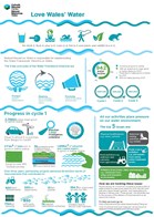
We have developed an Infographic - Love Wales' Water to promote the river basin management plans. If you would like an A4 poster version email us at wfdwales@cyfoethnaturiolcymru.gov.uk
The catchment summaries have been updated
They are intended to be a practical guide to aid the delivery of locally targeted actions and partnerships
- Carmarthen Bay catchment
- Clwyd catchment
- Conwy catchment
- Lleyn and Eryri catchment
- Meirionydd catchment
- Pembrokeshire catchment
- Tawe catchment
- South East Valleys catchment
- Teifi catchment
- Usk catchment
- Ynys Mon catchment
Water Watch Wales provides local information on classification, projects and measures.
The Severn River Basin Management Plan is led by the Environment Agency and is published on their website.
River Basin Management Plans are an existing measure under the Marine Strategy Framework Directive (MSFD) contributing to improving the state of the UK’s marine and coastal environments. The aim of the MSFD is for the UK to achieve Good Environmental Status in its waters by 2020. The full Programme of Measures which forms Part Three of the UK Marine Strategy is now published and available on the Welsh Government website.
Publication of Water Framework Directive (WFD) Regulations Cycle 3 Classification 2021 on the status of surface and ground WFD water bodies in Wales
At overall status across geographic Wales, 40% of 933 surface and ground water bodies are at good or better status. This represents an improvement of 3% from that reported in 2015 and an 8% improvement since 2009.
NRW now updates the classification every 3 years. The last classification of all water bodies was released in 2015 and an interim classification for surface water bodies in 2018. This is an update for all water bodies.
The classification is available on Water Watch Wales with a ‘Frequently Asked Questions’ document.